Mapping Haitian History
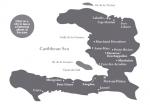 Historic sites throughout Haiti speak to resistance, perseverence, and the long struggle for freedom. Unfortunately, many of these sites are now falling apart. Stephanie Curci has created a website that is both map and visual record of Haiti's historical sites. She plans to expand the number of sites represented and make it interactive so visitors can post their own photos and narratives. Stephanie welcomes feedback at scurci@andover.edu. In the meantime, below is an article she wrote for the Journal of Haitian Studies on preserving and reintegrating Haiti's unique historical legacy.
Mapping Haitian History: A Photo Essay
By Stephanie Curci
Camp Gérard is one tap-tap and a motocyclette ride inland from Les Cayes, through the sweet green vetiver that reminds me of the rice fields of the Artibonite Valley. The hills are greener here in the South, however, and more wooded, giving hints of the lush Park Macaya over the nearby western horizon. The climb up to this small knoll-top fort is easy. Like Crête-à-Pierrot in Petite Rivière, Camp Gérard isn’t nearly as high as many of the mountaintop fortresses elsewhere in the country, yet the whole clear, level plain can be seen from this small hillock. One of the three wealthiest centers of colonial plantation life on the island (along with the Northern Plain and Cul de Sac), it is still neatly divided into carreaux of varying green plots, much as it was in 1803 when Dessalines and Geffrard met here to make their crucial alliance. A squat concrete pedestal with a plaque commemorating the historic meeting marks the site. While the stonework has not been well maintained, the ruins are perhaps more beautiful for the views offered through the broken walls. The fort is nearly deserted except for a woman lying in the shade of a stone wall, arm tossed across her face, singing plaintively to Zaka. Nearby, her young daughter plays in the dirt.
It would be entirely possible to become an expert on the Haitian Revolution, Haiti’s preeminent historical event, without seeing the land itself, but research and site visits can and should build off one another. Unfortunately, Haiti’s historical ruins are disappearing — for myriad reasons. Take, for example, one of the whimsically named residences Henri Christophe placed around the country: the Palais de 365 Portes in Petite Rivière, one of the most famous sites in the country. In the mid-1990s, it was in beautifully restored condition with several agencies, a dispensary, and a school taking up discrete sections of the long, low stone structure. Now, it is graffiti-covered and tempest-torn, its metal roof partially peeled off by a hurricane. The main entrance is padlocked, the doors diagonally barred, and barbed wire covers all the windows. On the back side of the palace, which looks up towards Crête-à-Pierrrot, many of the tall, thin, arched windows are pulled open, exposing the graffiti inside.
The Mapping Haitian History Project seeks to create an extensive and collaborative online visual record in English, Kréyol, and French that scholars and researchers, historical enthusiasts, schoolchildren, tourists, and adventure travelers can use. The project also seeks to preserve a record as future reference for restoration and preservation. For example, researchers would be able to see the surfaces and distinct shapes of the forts in Mirebalais and Saint Marc even if the sites endure further deterioration or destruction. A military historian could refer to project photos to see the embrasures in the bushes of Fort Anglais (on an island in the bay of St. Louis du Sud) and extrapolate the presence of artillery that has since disappeared. Today, old colonial habitations still have intact wooden structures; dry aqueducts still line rice paddies in the Artibonite. The visual records of the structures and layouts enable an understanding of the economic stakes of the Revolution. To see these structures is to understand directly the colonial sense of inevitability towards slavery: it is written into the stones littered across the island. To see these ruins is to view the lives of both the privileged and the oppressed through the crumbling structures of their history.
The scarcity of visual records is matched by the absence and inaccessibility of a coherent and cohesive collection of textual information on historical sites. Thus, in addition to the visual record, the Mapping Haitian History Project will serve as a virtual information clearinghouse. Ironically, some of the best resources for the project have been reports about tourism projects that have yet to be fully realized and research by the French Government on its own historical patrimony in Haiti (Charlery 2004, Maheux 2003). Just recently, I chanced upon Le Livre blanc — 1997, a collection of documents containing dozens of pages of tables for each department, town, and section: sites historiques, lieux mystiques, grottes, plages, et vues panoramiques. The government’s own Primalnfo publication from September 2006 highlights the issues of patrimony and tourism with a long list of prominent sites by department. Further, the map of Haiti’s Primary Cultural Sites, part of the 1996 Master Plan, is a visual if vague indicator of the wealth of sites across the breadth of the nation (Olsen 2003). This information could easily be made accessible, more clearly mapped, and democratized. These tables and maps have already been created by the Haitian government. They should be published on the government’s tourism Web site along with photos to give travelers and researchers alike an idea of the beauty and vast scope of Haiti’s resources. The Institut de Sauvegarde du Patrimoine National (ISPAN) and the Département de Culture are refurbishing the old prison in Cap-Haïtien into an elegant and first-class center for tourism and cultural information. Haiti is ripe to begin welcoming the same sort of adventurous, self-guided travelers who have explored so much of the Dominican Republic and the rest of the Caribbean and Central America. It is imperative that these sites are photographed before they exist only as a list of former sites. While there are current ISPAN, UNESCO, and other NGO-sponsored rehabilitation/restoration/stabilization projects on some notable sites, there are hundreds, if not thousands, of others that are undocumented — visually or otherwise — and are being destroyed.
Often, forts and old factories are taken apart stone by stone and brick by brick to be used in construction, cannons are stolen an melted down, and the ruins of mills are destroyed for farmland. Without the tourism dollars or historical organizations that would make keeping or restoring many of these ruins feasible and even profitable, most are soon to be only memories or mere shadows of what they are now. This is particularly so in the countryside; in bigger communities, ruins have higher visibility, while in rural areas, they are rarely remarked upon or protected at all. While forts are the most documented sites in text and photo, the clustering of historical sites seems to beg for a coordinated effort; mostly it is the more accessible sites of Port-au-Prince and Cap-Haïtien that are known, photographed, and visited. While Mapping Haitian History covers the entire country, three key areas of historical and cultural interest deserve more deliberate attention: the Cayes/Camp Perrin/St. Louis du Sud triangle, the Artibonite Valley, and the north/northeastern coast outside Cap-Haïtien itself and the Milot complex of Sans Souci, Citadelle Laferrière, and Ramiers. To facilitate the preservation of these more obscure sites, a small, grassroots local industry catering to history — , eco — , and adventure-tourism could employ guides, landscapers, translators, researchers, et al., and stem — if only slightly — the flood of urban migration. The Cayes/Camp Perrin/St. Louis du Sud triangle is an area rich in natural and historical resources. Unfortunately, in the town of Les Cayes, the remains of two important fortifications — La Tourterelle and the Fort Ilet — are underwater; the sea has “manje yo.”
However, in addition to Camp Gérard mentioned above, there is also the Fortresse des Platons, a several hours’ hike above the nearby town of Chantal. Further east along the Southern coast, St. Louis du Sud features several forts and a downtown park filled with cannons. According to locals, “researchers” recently surveyed the many rich forts and cannons of this former English stronghold, a major port of the south later eclipsed by nearby Les Cayes. Soon after, a helicopter made a midnight raid on the town’s island fort, Fort des Anglais, and stole a bronze cannon, the townspeople watching as their history was lifted away by cables and carried east across the sky. With the scrap-metal industry growing so rapidly in Haiti, the only thing saving the unprotected cannons is their large size and weight. Each one, however, is a historical code representing the cruel and protracted battles that may have claimed one of Leclerc’s cannons marked RF (for République Française) for Toussaint. While Fort des Anglais is accessible only by boat, Fort Olivier at St. Louis du Sud is on a green flat finger of land that juts out into the western half of the bay, covered in the tallest palms: it is simply stunning. In addition to being an important memorial to the convoluted struggles between the English and French to gain dominance over the western half of Hispaniola, Fort Olivier is also a site of soccer matches and a quiet area of repose on a remote edge of town.
While the entire Les Cayes plain is rich in former plantations, the road running from Les Cayes to Camp Perrin seems particularly rich and accessible. Camp Gérard features several prominent sites, including the Pemerle habitation just south of the fort in a village that shares its name. Surrounded by walls and outbuildings, two unusual rectangular stone towers front the main house. Another squat concrete plaque from the Presidential Bicentennial Commission memorializes the home of Martial Pemerle, one of the first to fight for liberty in the “zone des platons.” Continuing south, the Laborde sugar cane plantation is another interesting example. At one time thousands of acres, Count Laborde’s plantation is spread across several villages and can be found on the Les Cayes — Camp Perrin road. Behind the large Catholic church in the town of Laborde are some ruins including a fantastic cobblestone well, wide and very deep, enmeshed with neighboring trees. Closer to the road are some well-made, stone-lined tunnels tall enough to stand in, only partially excavated. In addition to these sites related to the Haitian Revolution and early nation, there are numerous other sites worthy of preservation and national recognition in the Les Cayes area.
On beautiful nearby Île à Vache, already a burgeoning tourist destination, amateur archeologist Clark Moore brought to my attention the significant pre-Columbian shell mounds near Cay Coq. Approximately eight feet tall and 400 square feet around, they are being scooped out from the center for decoration, jewelry-making, etc., but their stubborn existence still bears witness to the former life of this island. Near Camp Perrin, the caves of Counoubois/Conoubwa (also referred to elsewhere as simply the Camp Perrin caves) are significant sites of pre-Columbian petrogylphs and lie just a half-hour out of town. In addition to the waterfall of Saut Mathurine a two-hour hike north, these grottoes deserve environmental preservation to maintain their relatively pristine condition. These important natural and historic sites should be more fully integrated into the beach-resort tourism efforts stretching from Les Cayes to Port Salut.
In the center of the country, the Artibonite sites of Marchands/ Dessalines, Saint-Marc, and Petite Rivière are fairly easily accessible off Route Nationale 1, but their historical tourism potential has been largely under-utilized. Marchands/Dessalines, in particular, is an example of a rich site — one of many — that seems nearly unknown, certainly in photos. Five forts circle the town, each on a separate, steep walk above the small, well-planned city grid. After independence, the Haitian military relied on mountaintop forts unreachable by European naval cannons. Their presence evokes — in addition to Dessalines’s attempt to make this the well-fortified capital of the new nation — the history of marronage and guerilla fighting that would continue with the “Cacos” of the American occupation of 1915-1934. More humble still are two early national sites in Marchands/ Dessalines, the town center. With much of their original shingling, it seems, the beautifully restored homes of Charlotin Marcadieu — one of Dessalines’s colonels — and that of Claire Heureuse, Dessalines’s wife, sit unmarked.
This town, more than any other, seems a crucial memorial to the fierce determination and vulnerability of the new nation. Further south, in addition to the Palais de 365 Portes, Petite Rivière features the famous battle site of Crête-à-Pierrot. While restoration of the former site honors the vision and ambition of the new nation, the latter highlights the difficult siege of 1802 and its ironic role as one of many foreign forts retaken and refortified by the Haitian forces. Armed with a copy of the battle plan (available online from the The Louverture Project), any tourist can stride to the top of this short hilltop fort and picture clearly where Toussaint, Belair, or Rochambeau would have placed troops. Low, whitewashed concrete walls flank the rectangular perimeter, and only a small squat building in the center and some cannons mark this clearly as the site of a former fort. The view — encompassing a rich, green valley to the east and brown deforested mountains in the west — is stunning.
The burnt bark of an old mahogany tree inside the grounds, which cups offerings amidst its roots, reminds the visitor that this is hallowed ground. The sugar mills of the Artibonite Valley, and the Saint-Marc Valley in particular, offer a striking reminder of the myriad ways in which historical sites are not merely static sites of national memory; colonial structures, chaudière, and crushers from the 1600s, 1700s, and 1800s are constantly dismantled and repurposed. Outside Verrettes, for instance, bêtes still pull the long arms of a small wooden frame with three fat wooden crushers at its heart on a horizontal axis. While parts of the structure feature newer wood, this mill has been part of the family since the 1700s; the family still makes delicately spiced sirop in recycled Barbancourt bottles. There is one old mill in downtown Saint-Marc, just north of Rue Pivert, a broad main thoroughfare perpendicular to Route Nationale 1. Ten minutes by motocyclette further inland, however, is the more impressive and less frequently visited Guillon plantation. In “In Situ No. 3,” an article that forms part of a French government cultural inventory and research project, there is a description of the plantation, but no pictures (Maheux 2003). The lack of photos is an unfortunate omission, as it is a striking, if neglected, site. Although several outbuildings are falling apart, the two main structures are largely intact with their original tiling and wooden ceilings. The last mill in use was a British piece of machinery built in Liverpool in 1860; it can still be seen below the stone aqueduct that once ran its wheel. Currently, there is a tree nursery where cocoyiers and palms in black plastic containers sit side by side with the cast-iron cauldrons that would have heated sugar syrup. Centuries-old bagasse (the dried, crushed cane left over from the refinement process) is packed thick here and all over the valley, often side by side with the sharp freshly-cut sugarcane which will be processed much as it has been for centuries. While the mills suggest the changing nature and scope of agricultural development in the Artibonite, the forts along Saint-Marc’s coast are a tangible reminder of the battles fought to exploit its resources. Fort Blockus (also written as “Blockos” and “Blockhaus”) is the more dilapidated but accessible of the two sites. At the top of the hillside neighborhood that shares its name, its short, rounded, west-facing defensive walls are its most prominent feature, but vines choking the structure threaten to loosen and pull apart the stones.
The nearby fort on Point Diamant is a more impressive structure, accessible via a twenty-minute steep climb to the southern-facing fortifications. While the higher walls are disintegrating, some interior rooms are visible, and the defensive walls that form the basic structure of Fort Diamant show its original size and purpose. Most interesting, perhaps, are the stunning ocean views south and northwest and the multiple cannons. Their fascinating engravings (P; J.R.A. T.F.; A.M.; No. 283, etc.) deserve deciphering by a military historian who can translate their stories. One cannon marked 1846 suggests the fort’s continuing military purpose by the new nation. These forts could be combined with the sites at Petite Rivière and the colonial and current sugar mills of the Valley to form a potent visual historical narrative of the revolutionary and early national period. The north of the country is the area best known for its historical ruins. However, the focus tends to be on the architecture of Cap-Haïtien’s Carenage neighborhood and the UNESCO World Heritage Site at Milot: Citadelle Laferrière, Sans Souci, and Ramiers. However, there are important sites just outside Cap-Haitien and in Fort Liberté that deserve further recognition and preservation. The three fortifications just north of the city are easily accessible and maintain extensive artillery: Fort Etienne Magny (which is more properly a battery than a fort), Fort Saint Joseph, and Fort Picolet. Due east, near the tourist beaches at Labadie, Fort Belli lies covered in vines above a small, privately renovated inn called Norm’s Place. These ruins’ proximity to the Royal Caribbean complex suggests an educational opportunity for the hundreds of thousands of tourists who visit its beaches. Ruins on the resort property are roped off, their cultural and historical importance barely noted. At the northern edge of the town of Fort-Liberté, Fort Liberté itself juts north into the bay. Also known as Fort Saint Joseph and formerly known as Fort Dauphin (for the French prince), it is well preserved and shows signs of recent restoration.
The forts that line the northeastern shores of the bottleneck at the northern top of the bay are less accessible and poorly maintained.Forts Saint-Frédéric and Saint-Charles are small fortifications on the way, by boat, to the more impressive Fort Labouque. When one lands by water, the first sign of this last fortification is a small outbuilding, perhaps a gunpowder magazine, with a nearby well. A rusted, ocean-battered cannon lies further north, embedded in the bleached coral. Fort Labouque itself is a building surrounded by rounded walls only a few feet from the surf. Within the outer walls, a tall tunnel lining the entire interior runs the length of the circle. The fort itself has crumbled buildings and cannons lying among the weeds.
Residents of the district between Cap and Fort Liberté frequently build their houses with brick scavenged from colonial-era ruins. These ruins surely vary in size and significance, but one in particular stands out: the Habitation Duplat in Quartier Morin outside Cap-Haïtien just north of the Cap-Fort Liberté road. (This was called the Habitation Duplat by locals, but I have also read Habitation Dupuy elsewhere). Whitewashed brick walls and a tunneled stairway still stand around the main house’s perimeter; Within are an earthen floor and water-filled basins. To the left and right of the house are tunnels and wells. Across a scrub field, a tall chimney stands alone. Incredibly, a mapou has grown around a low arched doorway of a building that has otherwise disappeared. It’s unclear if the mapou holds up this stone archway or the other way around, but it has created a lovely buttressing effect. Behind the main house are the brick ruins of a colonial sugarcane processing factory; piles of bricks are set aside for sale. There is a sort of ironic and poetic justice in descendants of slaves, whose slavery-era housing had often been the first to disappear, dismantling what is very much a symbol of their ancestors’ oppression to make a solid home more substantial and durable than a caille-paille (straw hut). However, in addition to threatening the integrity of the structures themselves, this practice threatens another important site of historical and cultural memory. The legendary Lovanna aux Pierres is believed to swim in the water of the habitation basin. A magical fish with silver earrings, it is reputed to grant wishes to vodouisants who can catch a glimpse of it. Worshippers come every Tuesday and Friday, so the remains of cornmeal vévés are always found on the building’s earthen floor. There is a large annual fête there each September 27. This is another example of historical and cultural repurposing. Still within Quartier Morin but further south along a tree-lined avenue back to the Cap-Fort Liberté road, two pillars mark the entrance to Habitation Detreille. Like Habitation Guillon, this site was cited and even shown briefly in a French study of colonial homes, “In Situ No. 5” (Charlery 2004). Only one picture in the article shows the pillared entrance, and the photograph unfortunately doesn’t include a close-up of the plaque on one of the columns: “Le travail est mon bonheur” (Work is my joy).
This cruelly ironic message at the entrance to a former sugarcane plantation from the age of slavery deserves its own photo alongside the photos of chimneys and chaudières. This habitation, like so many others, represents slavery and the neo-slavery of post-independence forced labor, but it also provides a vantage point for observing the colonial period from the inside out. There is a way to look at the colonial period, not with nostalgia as is done on many islands throughout the Caribbean, but as a process of bearing witness. This memorializing of the past needs to be further reconciled with the needs and uses of the present. Historical recognition and preservation can be an expensive process, and the dire socioeconomic exigencies of the present cannot be ignored. This could make the issue of patrimony an ethically ambiguous and difficult one. However, there is a way to move forward with historical preservation in an inclusive way that empowers local Haitians as the producers of historical meaning, rather than its victims. Furthermore, across the country, historical sites of memory are being recycled in myriad ways that bear their own recognition. Forts, in particular, are being reinvented as sites of worship and celebration. People pray and sing on top of forts from Mirebalais to Cap-Haïtien; community groups and schools run classes in the star-shaped fort closest to town in Marchands/Dessalines; soccer games are contested in the red dirt of Fort Ogé outside Jacmel, an hour’s climb from many players’ houses. In Fort Picolet in August 2007, cannons were scattered everywhere, and preparations were in place for a fête. Each ruined room, open to the sky, was dedicated to a different lwa. Ezili’s room was a collage of magazine photos that seemed reminiscent of an American teenager’s room. There must be space for both the history fraught with war and suffering and liberation and the present moment filled with celebration and invention.
Mapping Haitian History (www.mappinghaitianhistory.com) is a small part of the process of propelling forward the history of the island in an optimistic and meaningful way: archiving its ruins and sites of memory to draw attention to lesser-known places; offering a historical and cultural context for sites in the hope of encouraging visitors, research, and preservation; and focusing attention on the ways in which historically significant sites can — and are already — being integrated into the daily life of Haiti and Haitians. Forts are the sites with the best hope for preservation, and that’s why their images are featured here. Relatively simple and heavy stone construction and immovable cannons have long awaited the growing worldwide interest in the Haitian Revolution. The global academic world, particularly the former Atlantic colonial powers, seem more and more interested in the Haitian Revolution, the Black Atlantic, and the Age of Independence. Throughout the world, Haiti is frequently held up as the only truly successful slave revolt, the first black republic, a model and touchstone for slaves throughout the Americas. Additionally, in the United States (even, sometimes, at the high school level), more academic attention is being paid to how Haiti highlighted the multiple failures of the United States to live up to its foundational documents, the Declaration of Independence in particular. Finally, while Haiti’s many fortifications could symbolize the warfare and violence that continues to plague the earth, they are often in the most beautiful and isolated spots. For tourism potential alone, the forts of the nation offer sublime views as well as a powerful timeline - and topography - of the high stakes and sheer size of the imperial slavery project.
As Danny Glover makes his movie Toussaint in Venezuela, the real forts of the Revolution deserve recognition for their physical survival despite the odds; they deserve — as do all these sites — their own paradigm shift (a revolution, if you will) in how to memorialize, preserve, and reintegrate a historical past with a vibrant cultural present.
Add new comment