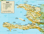
Mapping Haiti
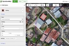
Ellen Ward (Concern Worldwide) writes below of the importance of accurate maps for promptly responding to disasters. In developing countries like Haiti, dense urban neighboods and isolated rural areas remain unmapped. The Missing Maps Initiative is an effort to fill in the blanks through crowd-sourcing. Concern and other partners have been involved in mapping neighborhoods of Port-au-Prince such as Bois Neuf, Cite Gerard, Cite Soleil in addition to communities affected by Hurricane Matthew. The Missing Maps Initiative website has resources for interested volunteers to learn how to map buildings and roads in Haiti and elsewhere using OpenStreetMap (supported by the OpenStreetMap Foundation). More information is also available on the Missing Maps Blog.